|
|


TechnoFILE is copyright and a registered trademark © ® of
Pandemonium Productions.
All rights reserved.
E-mail us Here!
Compton's Interactive World AtlasThe world, a mouse click away National Geographic, move over - Compton's Home Library has a new multimedia version of the venerable World Atlas. The Windows/Windows 95 CD-ROM is aimed at people aged ten years and up, and is going head to head with Microsoft's excellent Encarta Atlas for a slice of the home reference software market. The two Atlases have very different feels to them. Where Encarta lets you drag the world around to where you want to study, Compton's opens with a flat world map view and invites you to click on the section on which you want to focus. From there you're zoomed progressively closer to the surface, and the map gets more detailed. Or you can use the "locator globe" to find the section of Mother Earth you want to visit. Speaking of "Mother Earth," Compton's Atlas has a detailed, and very politically correct, selection of videos showcasing various aspects of the Earth. Some are straightforward information pieces, like the "Ring of Fire" (volcanoes and fault zones that surround the Pacific Ocean), but about half of them focus on topics like oil spills, global warming, endangered species, acid rain, etc. We don't know if Compton's is trying to make a political statement here, but we found ourselves wondering if the environmental lobby was involved in the planning of this title.
A toolbar across the top of the main window lets you access the Atlas's abundant features, and a toolbar on the left side controls the zooming and brings up a series of popup windows showing distances, the legend, etc. There's more in depth information offered, too. Clicking on the "Profile" button on the top toolbar takes you to a section from which you can access lots of information about the particular area of interest. A pulldown menu on this screen includes section on communications, defence, geography, etc. Compton's Atlas has some other interesting features. 3D flight, for example, lets you swoop gently over a virtual Earth, either in a pre-programmed flight path or one you create yourself. You can change your angle of view, your speed, etc., but you have to be in 256 color mode or it won't work - and even when it does work the screen is very pixelized. On the upside, a series of videos on various weather phenomena is quite interesting. The background information and the statistics are probably the best features of the Atlas, though we were also fascinated by the collection of satellite photographs, which range from space-based shots of cyclones, sunrises, and even a neat view of the Aurora Borealis - from above. A bonus is a selection of common phrases from some forty different languages, which you might find useful if you're planning a trip, and a measurement tool that lets you calculate distances. And, as with Compton's Encyclopedia, you can access an online resource, though it only works for American Online users. The maps aren't as detailed as they could be, nor is the zoom feature as good as it could be. The Encarta Atlas, for instance, lets you zoom from out in space to close enough that you can make out the major roads. No such detail is offered on the Compton's version, and unlike Encarta, you can't scroll your way around the world in one continuous move. Compton's Interactive Atlas is a good attempt - and has many worthwhile features - but we would have liked to see more attention paid to the actual maps.
|
|
|
|
|
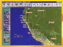 The
Atlas includes some 600 different maps - including more than 200 "political
maps" and 150+ elevation maps, "cultural videos," and the
usual collection of photographs (about 1500), music and audio clips (national
anthems, native music, etc.) and even a couple of hundred national flags.
You can customize your own maps, to a certain extent, by changing their
labels, and you can print them out, too .
The
Atlas includes some 600 different maps - including more than 200 "political
maps" and 150+ elevation maps, "cultural videos," and the
usual collection of photographs (about 1500), music and audio clips (national
anthems, native music, etc.) and even a couple of hundred national flags.
You can customize your own maps, to a certain extent, by changing their
labels, and you can print them out, too .| Support TechnoFile via Paypal |
| TechnoFILE's
E-letter We're pleased to offer our FREE private, subscription-based private E-mail service. It's the "no brainer" way to keep informed. Our Privacy Policy |