|
|


TechnoFILE is copyright and a registered trademark © ® of
Pandemonium Productions.
All rights reserved.
E-mail us Here!
Microsoft Virtual GlobeMultimedia Mother Earth The old fashioned Atlas has entered the late ‘90’s. Microsoft’s Virtual Globe, nee Encarta World Atlas, CD-ROM is an absorbing way to learn about "Parent Earth" and, while it can’t replace the solid feel of a book on your lap, it does let you circumnavigate the entire globe without turning a single page. Microsoft first introduced its multimedia atlas for the "1996 model year" and it was pretty neat, though it had a few minor problems. For instance, it was more than a touch ponderous and slow-running and at least one landmark, the Great Wall of China, wasn't there. Most of those glitches (including the Wall) have been addressed in subsequent versions, which are now a delight to use and, typically, offers many more features than earlier incarnations. The Atlas lets
you view the Earth from altitudes of between about 50,000 kilometres (where
it is when you load the disk) to 150 klicks, and the closer you get the
more detailed the map gets. It’s fascinating to zoom closer and watch
highways and other features suddenly appear before your eyes. (Right: zoom in and out) Want to find a city or a landmark? If you know where it is, just click on the little globe in the secondary window and drag the Earth around to where you want it. Or, if you want to see all the real estate that's on the way to your destination, just click your mouse at any edge or corner of the main map and move it around. And what a feeling of power you get being able to move the Earth at will! If you don’t know where your destination is, World Atlas has good search functions.
(Right: Satellite views, too!) Microsoft has come up with a really slick interface, with its "drag and drop" manipulation of the world. And the "pageless" nature of this Atlas means you can circumnavigate the globe in one fell swoop, pretending to take a "virtual flying tour" of our world. Along the way you’ll find interesting places and people: double click on some areas, like a selection of major cities, and you're whisked to a street map of the area. More than a dozen map styles, from political to tectonic, give a dizzying array of views - and the real tour de force is the satellite views that let you see Earth in her photographic glory both by day and by night. The night view is particularly beautiful as the world's cities glow like coloured diamonds in the darkness. And, similar to the Encarta Deluxe Encyclopedia's 360 degree panorama views, the Atlas offers a series of draggable 360 degree windows that are fascinating. There are even flora and fauna galleries that give some insight into who and what hangs out in a particular area. Microsoft Virtual Globe probably won't replace the print atlas - but it's sure a lot more fun than the old medium!
|
|
|
|
|
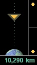 Likewise, it's fascinating to zoom outward and see the physical features
appearing as you head into space.
Likewise, it's fascinating to zoom outward and see the physical features
appearing as you head into space.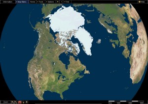 Microsoft
Virtual Globe contains more than 1.2 million places, "the most detailed
world atlas available anywhere," in the words of last year's packaging,
and it’s amazing how much stuff is crammed onto this disk. It isn’t
all there, however, and some of it is strange - for instance, TechnoFILE
is headquartered in Calgary, Alberta, and Encarta has a good representation
of the city, including a section called Montgomery, of which we've never
heard. Conversely, the mining towns of Sparwood and Elkford, British Columbia,
aren't on the map - but Natal (which used to exist but doesn't any longer)
is there in their place. Still, with so many places to include, it isn't
surprising some would be messed up.
Microsoft
Virtual Globe contains more than 1.2 million places, "the most detailed
world atlas available anywhere," in the words of last year's packaging,
and it’s amazing how much stuff is crammed onto this disk. It isn’t
all there, however, and some of it is strange - for instance, TechnoFILE
is headquartered in Calgary, Alberta, and Encarta has a good representation
of the city, including a section called Montgomery, of which we've never
heard. Conversely, the mining towns of Sparwood and Elkford, British Columbia,
aren't on the map - but Natal (which used to exist but doesn't any longer)
is there in their place. Still, with so many places to include, it isn't
surprising some would be messed up.| Support TechnoFile via Paypal |
| TechnoFILE's
E-letter We're pleased to offer our FREE private, subscription-based private E-mail service. It's the "no brainer" way to keep informed. Our Privacy Policy |